Get alerts of the antiques that interest you as soon as they are uploaded
£ 345
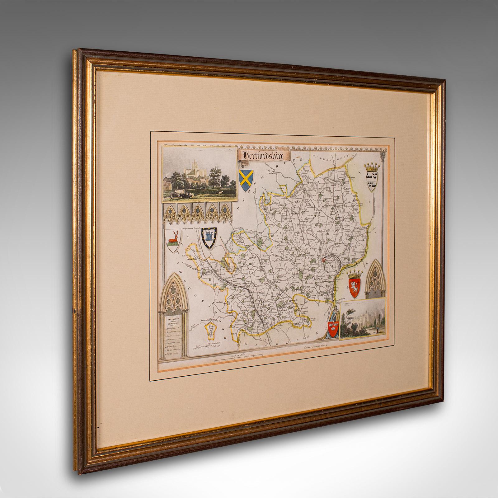
Antique County Map, Hertfordshire, English, Framed Engraving, Cartography, Litho
£ 345
London Fine Ltd
Elder Books & Collectables
1880's Folding Map of the North Pole with Arctic Explorers Expeditions Scarce
£ 375
1880's Folding Map of the North Pole with Arctic Explorers Expeditions Scarce
£ 375
Elder Books & Collectables
Art & Stuff
John Cary: 18th Century Map of Middlesex
£ 40
£ 395
Small Antique County Map, Northamptonshire, English, Framed, Cartography, c.1850
£ 395
London Fine Ltd
£ 345
Antique County Map, Rutlandshire, Framed Atlas Cartography, John Cary, Georgian
£ 345
London Fine Ltd
£ 595
Antique Coaching Road Map Cranborne to Dorchester, Framed Cartography, Victorian
£ 595
London Fine Ltd
£ 795
Antique County Map, Cambridgeshire, English, Framed Cartography, Robert Morden
£ 795
London Fine Ltd
£ 395
Antique Town Plan Map, Poole, English, Framed Cartography, Georgian c.1780
£ 395
London Fine Ltd
London Fine Ltd
Antique County Map, Hampshire, English, Framed Cartography, Robert Morden - 17th Century
£ 495
Antique County Map, Hampshire, English, Framed Cartography, Robert Morden - 17th Century
£ 495
London Fine Ltd
£ 595
Antique County Map, Shropshire, English, Atlas Engraving - Richard Blome c.1673
£ 595
London Fine Ltd
£ 795
Large Antique Lithography Map, Northamptonshire, Framed Cartography - John Speed
£ 795
London Fine Ltd
£ 585
Antique County Map, Northamptonshire, English, Framed Cartography, Richard Blome
£ 585
London Fine Ltd
£ 295
Antique Lithography Map, Warwickshire, English, Framed, Cartography, Victorian
£ 295
London Fine Ltd
£ 895
Large Antique Lithography Map of Kent, English, Cartography - Robert Morden, 1700
£ 895
London Fine Ltd
£ 695
Antique Lithography Map, Coastal England, Framed Cartography Interest, Victorian
£ 695
London Fine Ltd
£ 595
Antique Lithography Map, Environs of Southampton, English, Framed, Victorian
£ 595
London Fine Ltd
Elder Books & Collectables
1755 City Plan of London Langborn Ward & Candlewick Ward by John Stow Large Size
£ 85
1755 City Plan of London Langborn Ward & Candlewick Ward by John Stow Large Size
£ 85
Elder Books & Collectables
£ 295
Antique Lithography Map, Buckinghamshire, English, Framed Cartography - Victorian
£ 295
London Fine Ltd
£ 295
Antique Lithography Map, County Durham, English, Framed Cartography - Victorian
£ 295
London Fine Ltd
Elder Books & Collectables
1821 The Parish of Christ Church Surrey Scarce Hand Coloured London Plan
£ 75
1821 The Parish of Christ Church Surrey Scarce Hand Coloured London Plan
£ 75
Elder Books & Collectables
£ 59
£ 295
Antique Lithography Map, Worcestershire, English, Framed Engraving, Cartography
£ 295
London Fine Ltd
£ 295
Antique Coaching Road Map, South Devon, English, Framed, Cartography, Georgian
£ 295
London Fine Ltd
£ 295
Antique Coach Road Map, East Devon, English, Framed, Cartography - Georgian c.1720
£ 295
London Fine Ltd
£ 395
Antique Lithography Map, Black Sea, English, Framed, Cartography, Victorian
£ 395
London Fine Ltd
Elder Books & Collectables
1786 Miniature Map of Gloucestershire by E Bowen Hand Coloured in Maple Frame
£ 65
1786 Miniature Map of Gloucestershire by E Bowen Hand Coloured in Maple Frame
£ 65
Elder Books & Collectables
Elder Books & Collectables
1750 Miniature Map of Herefordshire by Thomas Osborne Hand Coloured Framed
£ 45
1750 Miniature Map of Herefordshire by Thomas Osborne Hand Coloured Framed
£ 45
Elder Books & Collectables
Elder Books & Collectables
1695 Large Hand Coloured Map of Monmouthshire South Wales by Robert Morden
£ 75
1695 Large Hand Coloured Map of Monmouthshire South Wales by Robert Morden
£ 75
Elder Books & Collectables
Elder Books & Collectables
Original 19th Century World Hemisphere Map West & East Coloured c.1850
£ 48
Original 19th Century World Hemisphere Map West & East Coloured c.1850
£ 48
Elder Books & Collectables
£ 85
£ 585
Antique Paterson's Guide to Britain, English, Maps, Georgian, Published 1811
£ 585
London Fine Ltd
Will Thomas - Architectural Antiques
1823 Map of England & Wales Including Principal Part of Scotland Map by William Darton
£ 550
1823 Map of England & Wales Including Principal Part of Scotland Map by William Darton
£ 550
Will Thomas - Architectural Antiques
Andrew Cox Antiques
Mid 19th Century Map of the County of Essex
£ 45
£ 65
£ 675
Antique Folding London Map, English, Cartography, Historic, Georgian, Dated 1783
£ 675
London Fine Ltd
Art & Stuff
John Cary: 18th Century Map of Derbyshire
£ 68
Elder Books & Collectables
1914-15 Collection of Early Mountaineering Journals The Alpine Journal + Maps
£ 180
1914-15 Collection of Early Mountaineering Journals The Alpine Journal + Maps
£ 180
Elder Books & Collectables
Elder Books & Collectables
1640s Hand Coloured Map of Yorkshire by Jan Jannson
£ 275
Art & Stuff
Robert Morden: Map of Staffordshire ca.1695
£ 125
Elder Books & Collectables
1834 County Map of Bedford by C & J Greenwood
£ 90
Get alerts of the antiques that interest you as soon as they are uploaded