£ 595
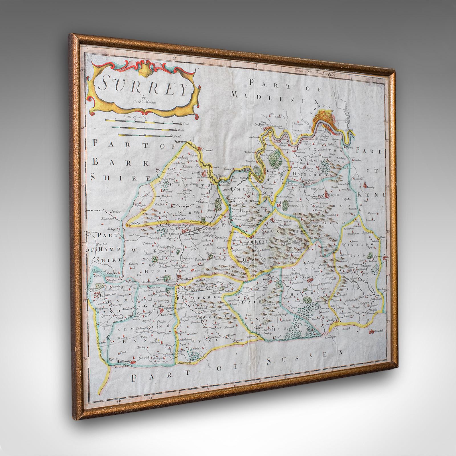
Antique Surrey Map, English, County Cartography, Atlas, Robert Morden c.1700
£ 595
London Fine Ltd
£ 395
Antique Dual Sided Carnarvonshire Map, Atlas Excerpt, North Wales, Cartography
£ 395
London Fine Ltd
£ 795
Antique Wiltshire County Map, Dutch, Framed Cartography, Latin, Blaeu c.1650
£ 795
London Fine Ltd
£ 495
Antique Town Plan, Portsmouth Dockyard, English, Framed Cartography - Victorian
£ 495
London Fine Ltd
£ 695
Antique Coaching Map, Salisbury to Campden, English, Framed Cartography, Ogilby
£ 695
London Fine Ltd
£ 450
£ 845
Antique Map of England & Wales, French, Framed Cartography - Georgian c.1780
£ 845
London Fine Ltd
Art & Stuff
Map of Cornwall by William Kip ca.1637
£ 195
£ 895
Antique Map of Surrey, English, Framed County Cartography, After Blaeu, C.1690
£ 895
London Fine Ltd
£ 895
Antique Italian Region Map, Framed Cartography, 18th Century, Emilia Romagna
£ 895
London Fine Ltd
£ 895
Antique Map of Ireland, French, Framed Cartography, Eire, Georgian, Circa 1780
£ 895
London Fine Ltd
£ 795
Antique Map of Scotland, French, Framed Cartography, Ecosse, Georgian, C.1780
£ 795
London Fine Ltd
£ 595
Antique Devon County Map, English, Framed 17th Century Atlas Cartography c.1650
£ 595
London Fine Ltd
£ 495
Antique Framed Cornwall Map, English, Atlas Cartography, Robert Morden, C.1700
£ 495
London Fine Ltd
£ 695
Antique Framed Gloucestershire Map, English Atlas Engraving, Cartography, C.1700
£ 695
London Fine Ltd
£ 895
Antique Cartographer's Serving Tray, English, Platter, European Map - Edwardian
£ 895
London Fine Ltd
Southwold Vintage and Antiques
A Royal Air Force Silk Escape Map Covering Libya,
£ 99
£ 795
Antique Map of Asia, French, Framed, Atlas, Continental Cartography, Georgian
£ 795
London Fine Ltd
£ 625
Antique Set of Architectural Plans, French, Framed Lithographs, Art c.1900
£ 625
London Fine Ltd
£ 895
Antique Jamaica Map, English, Caribbean, Cartography, Thomas Jefferys, Georgian
£ 895
London Fine Ltd
£ 925
Antique Suffolk County Map, Dutch, Atlas Novus, Joan Blaeu, Cartography c.1645
£ 925
London Fine Ltd
£ 1,395
Antique Gloucestershire Map, Atlas, English, Robert Morden, Cartography c.1700
£ 1,395
London Fine Ltd
£ 925
Antique Gloucestershire Map, English, Framed Cartography, Robert Morden, C.1700
£ 925
London Fine Ltd
£ 895
Antique Map of Bohemia, Dutch, Framed Cartography, Johannes Janssonius c.1630
£ 895
London Fine Ltd
£ 745
Antique Chester County Map, English, Cheshire, Framed Cartography - Georgian c.1770
£ 745
London Fine Ltd
£ 925
Antique Plan de L'historie Universelle World Map, Framed Cartography, Circa 1730
£ 925
London Fine Ltd
£ 595
Antique Caernarvon Map, Framed Cartography, Welsh County - John Speed c.1610
£ 595
London Fine Ltd
£ 695
Antique Stafford County Map, English, Atlas Engraving - 17th Century, Cartography
£ 695
London Fine Ltd
£ 795
Antique Buckinghamshire Map, English, Framed 17th Century County Cartography
£ 795
London Fine Ltd
£ 685
Antique Lincolnshire Map, English, County Cartography - Robert Morden c.1900
£ 685
London Fine Ltd
£ 895
Antique South America Map, English, Framed Cartography, De La Rochette, Georgian
£ 895
London Fine Ltd
£ 525
Antique Road Map, London to Hythe, Kent, English, Cartography, John Ogilby 1675
£ 525
London Fine Ltd
£ 595
Antique County Map, Cornwall, Kernow, English, Framed - Robert Morden - Georgian
£ 595
London Fine Ltd
£ 575
Antique County Map, Cheshire, English, Framed Cartography, Robert Morden, 18th.c
£ 575
London Fine Ltd
Newark Antiques and Interiors Ltd
World War One Trench Map Hazebrouck 5A
£ 150
Art & Stuff
Morden: Map of Gloucestershire 1722
£ 125
London Fine Ltd
Antique Devonshire Map, English Framed Robert Morden Devon Cartography - Georgian c.1720
£ 495
Antique Devonshire Map, English Framed Robert Morden Devon Cartography - Georgian c.1720
£ 495
London Fine Ltd
Stalham Antique Gallery
Very Attractive & Unusual Sampler in the Form of Map
£ 580
Fox & Hare Antiques & Interiors
18th Century Hand- Coloured Map Print - Ashburton To Plymouth Devon - c.1760
£ 35
18th Century Hand- Coloured Map Print - Ashburton To Plymouth Devon - c.1760
£ 35
Fox & Hare Antiques & Interiors