Get alerts of the antiques that interest you as soon as they are uploaded
£ 595
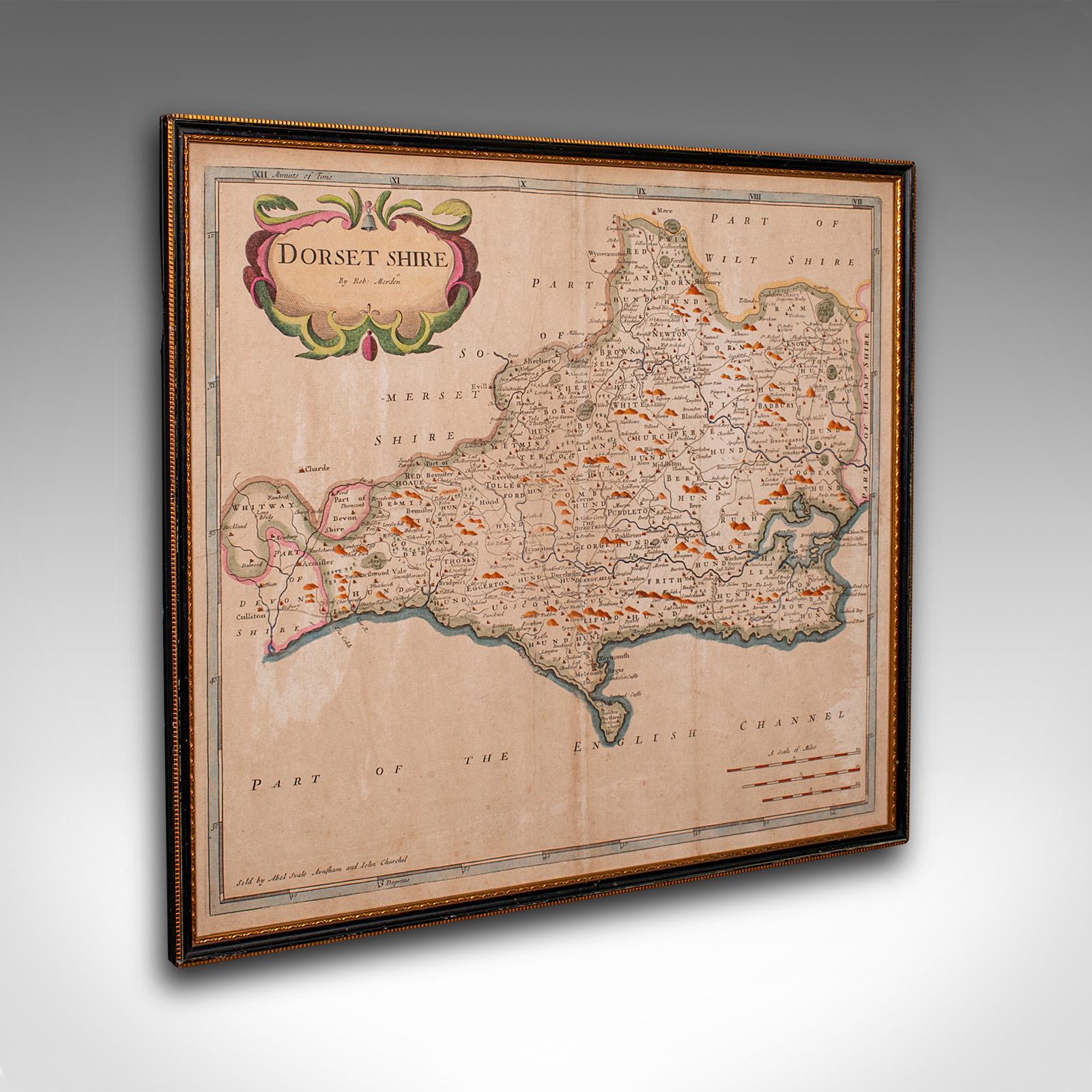
Large Antique 17th Century Dorset Map, Framed Cartography, Atlas, Robert Morden
£ 595
London Fine Ltd
Graham Deakin Antiques
18th Century Map by Edward Hasted
£ 110
Art & Stuff
Saxton & Hole: Map of Berkshire Ca. 1637
£ 145
Art & Stuff
Robert Morden: 17th Century Map of Hampshire
£ 125
Antique and Unique
Seventeenth Century Road Map by John Ogilby
£ 110
£ 595
Antique North America Map, Usa, Canada, Mexico, Cartography, Colton, Victorian
£ 595
London Fine Ltd
£ 895
Antique Lithography Map, Oxfordshire, English, Framed Cartography - Robert Morden
£ 895
London Fine Ltd
£ 295
Antique North Yorkshire Map, English, Framed Lithography, Cartography, Victorian
£ 295
London Fine Ltd
£ 295
Antique County Map, Berkshire, English Framed Lithograph, Cartography, Victorian
£ 295
London Fine Ltd
£ 295
Antique County Map, Sussex, English, Framed Lithography, Cartography c.1860
£ 295
London Fine Ltd
£ 295
Antique East Yorkshire Map, English, Framed Lithograph, Cartography, Victorian
£ 295
London Fine Ltd
£ 295
Antique County Map, Surrey, English, Framed Lithograph, Cartography, Victorian
£ 295
London Fine Ltd
£ 295
Antique County Map, Middlesex, English, Framed, Litho, Cartography - Victorian
£ 295
London Fine Ltd
£ 795
Antique County Map, Buckinghamshire, Bedfordshire, Dutch, Framed, Janssonius
£ 795
London Fine Ltd
£ 295
Antique Lithography Map, Cambridgeshire, English, Framed Cartography c.1860
£ 295
London Fine Ltd
£ 295
Antique Lithography Map, Monmouthshire, Framed, Welsh Cartography c.1860
£ 295
London Fine Ltd
£ 295
Antique Lithography Map, Derbyshire, English, Framed Cartography, Victorian
£ 295
London Fine Ltd
£ 295
Antique Environs of Bath & Bristol Map, English, Framed Cartography c.1860
£ 295
London Fine Ltd
£ 295
Antique County Map, Staffordshire, English, Framed Litho, Cartography - Victorian
£ 295
London Fine Ltd
£ 295
Antique Lithography Map, Huntingdonshire, English, Framed Cartography c.1850
£ 295
London Fine Ltd
£ 365
Antique Berkshire Map, English County, Framed Engraving, Cartography, Lithograph
£ 365
London Fine Ltd
£ 345
Antique County Map, Hertfordshire, English, Framed Engraving, Cartography, Litho
£ 345
London Fine Ltd
Elder Books & Collectables
1880's Folding Map of the North Pole with Arctic Explorers Expeditions Scarce
£ 375
1880's Folding Map of the North Pole with Arctic Explorers Expeditions Scarce
£ 375
Elder Books & Collectables
£ 1,295
Antique County Map of Cheshire, Dutch, Framed, Cartography, Janssonius c.1660
£ 1,295
London Fine Ltd
Art & Stuff
John Cary: 18th Century Map of Middlesex
£ 40
£ 395
Small Antique County Map, Northamptonshire, English, Framed, Cartography, c.1850
£ 395
London Fine Ltd
£ 345
Antique County Map, Rutlandshire, Framed Atlas Cartography, John Cary, Georgian
£ 345
London Fine Ltd
£ 595
Antique Coaching Road Map Cranborne to Dorchester, Framed Cartography, Victorian
£ 595
London Fine Ltd
£ 495
Antique Road Map, Bristol to Weymouth, English, Framed Cartography, Georgian
£ 495
London Fine Ltd
£ 795
Antique County Map, Cambridgeshire, English, Framed Cartography, Robert Morden
£ 795
London Fine Ltd
£ 395
Antique Town Plan Map, Poole, English, Framed Cartography, Georgian c.1780
£ 395
London Fine Ltd
London Fine Ltd
Antique County Map, Hampshire, English, Framed Cartography, Robert Morden - 17th Century
£ 495
Antique County Map, Hampshire, English, Framed Cartography, Robert Morden - 17th Century
£ 495
London Fine Ltd
£ 595
Antique County Map, Shropshire, English, Atlas Engraving - Richard Blome c.1673
£ 595
London Fine Ltd
£ 795
Large Antique Lithography Map, Northamptonshire, Framed Cartography - John Speed
£ 795
London Fine Ltd
£ 585
Antique County Map, Northamptonshire, English, Framed Cartography, Richard Blome
£ 585
London Fine Ltd
£ 295
Antique Lithography Map, Warwickshire, English, Framed, Cartography, Victorian
£ 295
London Fine Ltd
£ 895
Large Antique Lithography Map of Kent, English, Cartography - Robert Morden, 1700
£ 895
London Fine Ltd
£ 695
Antique Lithography Map, Coastal England, Framed Cartography Interest, Victorian
£ 695
London Fine Ltd
£ 595
Antique Lithography Map, Environs of Southampton, English, Framed, Victorian
£ 595
London Fine Ltd
Elder Books & Collectables
1755 City Plan of London Langborn Ward & Candlewick Ward by John Stow Large Size
£ 85
1755 City Plan of London Langborn Ward & Candlewick Ward by John Stow Large Size
£ 85
Elder Books & Collectables
Get alerts of the antiques that interest you as soon as they are uploaded